ELM Background
Since 2009, the Minnesota based nonprofit SharedGeo has been involved in research to determine the optimum way to create a marker for hiking and outdoor recreation trails and other rural scenarios where there is a need to denote a location for an emergency response. This effort has been in response to two significant problems that plague virtually all existing approaches:
1.) Current markers of this type are jurisdicitonally unique and consequently do not facilitate understanding or coordination if response resources must be brought in from outside a region for an event like a wildfire, and
2.) Current marker systems do not work with GPS.
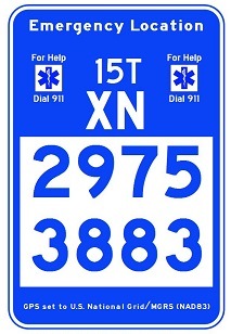
Through SharedGeo’s efforts, it has been determined that both these problems can be solved by using a sign design that leverages the U.S. National Grid (USNG) – the U.S. portion of the worldwide Military Grid Reference System (MGRS) – and which conforms to various national and international display standards. The result of this marker design effort, now known as a USNG Emergency Location Marker (ELM), is shown to the left and above. Because this sign style provides for the report of an emergency location based on a GPS coordinate system (USNG), response efforts are significantly enhanced.
Work on this project originally commenced as a collaborative effort between the MnGeo Emergency Preparedness Committee and SharedGeo. A Local Operational Research Program (OPERA) grant to the City of St. Paul helped fund initial marker field trials. For more information about developments to date, please see the links below:
- Minnesota Marker Signs Might Look Funny – Until You’re Lost and Need One, Pioneer Press article, May 13, 2013, Julio Ojeda-Zapata
- U.S. National Grid Trail Markers – Bringing Geolocation to a Trail Near You, Power Point presentation, October 4, 2012, Minnesota GIS/LIS Consortium Conference, St. Cloud, Minnesota, Steve Swazee, Bob Babques