Data
USNG data are available, usually in GIS Shapefile format, from the National Geospatial-Intelligence Agency (NGA) and from other providers that have created their own data, such as SharedGeo and the USNG National Implementation Center (TUNIC) at Delta State University.
Links to data sources are provide below and organized by FEMA regions, and USNG grid zones, and individual states.
Data by FEMA Regions
Click on FEMA region in map or use link in table below to go to data download page.
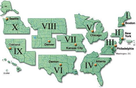
| Region | States Serving | Download Data |
|---|---|---|
| Region I | CT, MA, ME, NH, RI, VT | Data for Region I |
| Region II | NJ, NY, PR, USVI | Data for Region II |
| Region III | DC, DE, MD, PA, VA, WV | Data for Region III |
| Region IV | AL, FL, GA, KY, MS, NC, SC, TN | Data for Region IV |
| Region V | IL, IN, MI, MN, OH, WI | Data for Region V |
| Region VI | AR, LA, NM, OK, TX | Data for Region VI |
| Region VII | IA, KS, MO, NE | Data for Region VII |
| Region VIII | CO, MT, ND, SD, UT, WY | Data for Region VIII |
| Region IX | AZ, CA, HI, NV, GU, AS, CNMI, RMI, FM | Data for Region IX |
| Region X | AK, ID, OR, WA | Data for Region X |
Data by Grid Zone
 |
NGA Data: Worldwide, continent, UTM zone data and example data – Worldwide, continental, UTM zone shapefiles and example 1km and other files available on GIS MGRS page from the National Geospatial-Intelligence Agency (NGA). |
 |
NGA Data: UTM zone descriptions and data – A good overview of UTM Zones from the National Geospatial-Intelligence Agency (NGA). This page explains how UTM zones are the basis for MGRS Grids. UTM Zone shapefiles area available for download and links to 100km grid download available (also listed below). |
 |
NGA Data: 100km grids – 100 km shapefiles and related files available via clickable map from the National Geospatial-Intelligence Agency (NGA). |
 |
MGRS Data Website – The mgrs-data.org website offers downloads of MGRS data. A country and city look up is available to find the correct zone.. |
Data by State (100m)
In response to a growing number of requests, in spring 2020, SharedGeo generated 100 meter USNG shapefiles for each CONUS state and Washington D.C. Each ZIP file includes shape files for every 100km grid zone that intersects the state. Thus, there is overlap with adjacent states, and if all ZIP files are downloaded, there will be some duplicate shapefiles across states. The entire CONUS data file is about 55GB zipped, and 148GB uncompressed (w/o duplicates).
States:
Districts and Territories:
– Washington, District of Columbia
– Others as requested